Soubor:Paris europe train map fr.png
Větší rozlišení není k dispozici
Paris_europe_train_map_fr.png (552 × 600 pixelů, velikost souboru: 129 KB, MIME typ: image/png)
| Tento soubor pochází z Wikimedia Commons. Níže jsou zobrazeny informace, které obsahuje jeho tamější stránka s popisem souboru. |
| Popis |
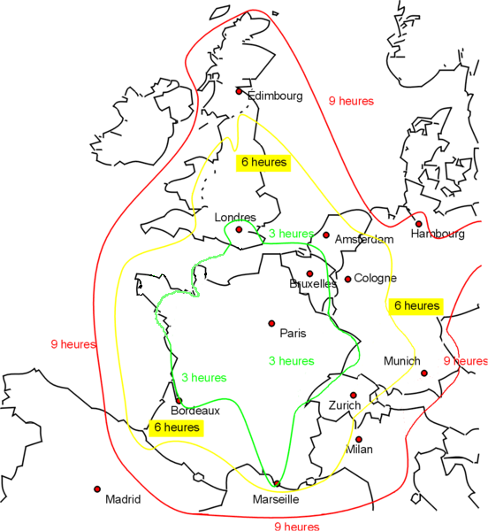
Français : Duree de voyage de Paris avec le train. |
||||||||
| Datum | |||||||||
| Zdroj | Based on File:paris_europe_train_map.png | ||||||||
| Autor | Rnt20 | ||||||||
| Svolení (Užití tohoto souboru) |
|
||||||||
| Další verze |
|


| date/time | username | edit summary |
|---|---|---|
| 21 janvier 2006 à 00:04 | Frombenny | |
| 31 mai 2005 à 21:48 | Rnt20 | |
| 31 mai 2005 à 21:47 | Rnt20 | |
| 31 mai 2005 à 16:27 | Rnt20 | (Duree de voyage de Paris avec le train. Base sur <a href="http://en.wikipedia.org/wiki/Image:paris_europe_train_map.png" class='extiw' title="en:Image:paris europe train map.png">:en:Image:paris_europe_train_map.png</a> Du Bob Tubbs {{PD-self}} ) |
Historie souboru
Kliknutím na datum a čas se zobrazí tehdejší verze souboru.
| Datum a čas | Náhled | Rozměry | Uživatel | Komentář | |
|---|---|---|---|---|---|
| současná | 9. 12. 2009, 20:57 | | 552 × 600 (129 KB) | Dark Nark | Reverted to version as of 18:55, 9 December 2009 |
| 9. 12. 2009, 20:56 |  | 552 × 600 (129 KB) | Dark Nark | Changement de temps de parcours en Bretagne et dans le Cotentin. | |
| 9. 12. 2009, 20:55 |  | 552 × 600 (129 KB) | Dark Nark | Changement de temps de parcours au-niveau de la Bretagne. | |
| 6. 8. 2007, 19:39 |  | 1 024 × 1 113 (63 KB) | Rnt20 | {{Information |Description= |Source=self-made |Date= |Author= Rnt20 }} | |
| 31. 5. 2005, 22:56 |  | 1 024 × 1 113 (63 KB) | Rnt20 | Duree de voyage de Paris avec le train. Base sur Image:paris_europe_train_map.png (English version at Image:paris_europe_train_map.png) Apologies for any errors in my French translation! {{PD-self}} Category:Paris | |
| 31. 5. 2005, 21:33 |  | 1 024 × 1 113 (63 KB) | Rnt20 | Duree de voyage de Paris avec le train. Base sur Image:paris_europe_train_map.png Apologies for any errors in my French translation! {{PD-self}} |
Využití souboru
Tento soubor nepoužívá žádná stránka.
Globální využití souboru
Tento soubor využívají následující wiki:
- Využití na en.wikipedia.org
- Využití na fr.wikipedia.org
- Využití na ja.wikipedia.org
- Využití na pl.wikipedia.org
- Využití na roa-tara.wikipedia.org
- Využití na ro.wikipedia.org
- Využití na vi.wikipedia.org