Soubor:Mount Malinao.jpg
Větší rozlišení není k dispozici
Mount_Malinao.jpg (640 × 416 pixelů, velikost souboru: 43 KB, MIME typ: image/jpeg)
| Tento soubor pochází z Wikimedia Commons. Níže jsou zobrazeny informace, které obsahuje jeho tamější stránka s popisem souboru. |
Popis
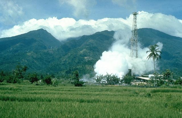
| Popis | Mount Malinao is a forested stratovolcano with a summit crater that is breached to the east. The Tiwi geothermal field, seen here with the volcano in the background, is located on the east flanks of Malinao. The geothermal field is located near Luzon's largest fumarole field, which includes siliceous sinter deposits at Naglabong. |
| Datum | neznámé datum |
| Zdroj | http://www.volcano.si.edu/world/volcano.cfm?vnum=070304=A&volpage=photos&photo=018037 |
| Autor | Chris Newhall (U.S. Geological Survey) |
Licence
Tento soubor je volné dílo, protože obsahuje materiály pocházející od United States Geological Survey (USGS), agentury Ministerstva vnitra USA. Pro bližší informaci vizte oficiální licenční pravidla USGS (anglicky).
|
Historie souboru
Kliknutím na datum a čas se zobrazí tehdejší verze souboru.
| Datum a čas | Náhled | Rozměry | Uživatel | Komentář | |
|---|---|---|---|---|---|
| současná | 11. 10. 2010, 20:00 | | 640 × 416 (43 KB) | Michael Metzger | {{Information |Description=Mount Malinao is a forested stratovolcano with a summit crater that is breached to the east. The Tiwi geothermal field, seen here with the volcano in the background, is located on the east flanks of Malinao. The geothermal field |
Využití souboru
Tento soubor používá následující stránka:
Globální využití souboru
Tento soubor využívají následující wiki:
- Využití na arz.wikipedia.org
- Využití na bcl.wikipedia.org
- Využití na de.wikipedia.org
- Využití na en.wikipedia.org
- Využití na fa.wikipedia.org
- Využití na fr.wikipedia.org
- Využití na ilo.wikipedia.org
- Využití na lld.wikipedia.org
- Využití na nl.wikipedia.org
- Využití na www.wikidata.org