Soubor:Map of Ukraine en.svg

Původní soubor (soubor SVG, nominální rozměr: 602 × 448 pixelů, velikost souboru: 1,28 MB)
| Tento soubor pochází z Wikimedia Commons. Níže jsou zobrazeny informace, které obsahuje jeho tamější stránka s popisem souboru. |
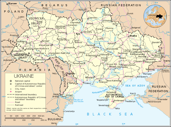
| Popis | Map of Ukraine | |||
| Datum | ||||
| Zdroj | http://www.un.org/Depts/Cartographic/map/profile/ukraine.pdf | |||
| Autor | United Nations Cartographic Section | |||
| Svolení (Užití tohoto souboru) |
|

Historie souboru
Kliknutím na datum a čas se zobrazí tehdejší verze souboru.
| Datum a čas | Náhled | Rozměry | Uživatel | Komentář | |
|---|---|---|---|---|---|
| současná | 17. 9. 2022, 16:05 | | 602 × 448 (1,28 MB) | Gzhegozh | names of cities updated |
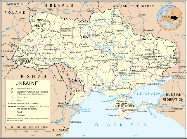
| 6. 1. 2011, 18:33 |  | 602 × 448 (1,28 MB) | Akhristov | Reverted to version as of 04:17, 5 April 2007: bug in rendering | |
| 6. 1. 2011, 18:32 |  | 753 × 560 (883 KB) | Akhristov | Updated version from UN (Sept 2008) | |
| 5. 4. 2007, 06:17 |  | 602 × 448 (1,28 MB) | Akhristov | {{Information| |Description=Map of Ukraine |Source=http://www.un.org/Depts/Cartographic/map/profile/ukraine.pdf |Date=January 2005 |Author=United Nations Cartographic Section |Permission={{UN map}} }} |
Využití souboru
Tento soubor používá následující stránka:
Globální využití souboru
Tento soubor využívají následující wiki:
- Využití na ba.wikipedia.org
- Využití na da.wikipedia.org
- Využití na en.wikipedia.org
- Využití na et.wikipedia.org
- Využití na fr.wikipedia.org
- Využití na hr.wiktionary.org
- Využití na it.wikipedia.org
- Využití na pam.wikipedia.org
- Využití na pl.wikipedia.org
- Využití na ru.wikipedia.org
- Využití na ta.wikipedia.org
- Využití na uk.wikipedia.org