Soubor:Map of Poland (1945).png
Větší rozlišení není k dispozici
Map_of_Poland_(1945).png (594 × 513 pixelů, velikost souboru: 13 KB, MIME typ: image/png)
| Tento soubor pochází z Wikimedia Commons. Níže jsou zobrazeny informace, které obsahuje jeho tamější stránka s popisem souboru. |
.png)

|
Tento obrázek (skupina historical map) by měl být vytvořen pomocí vektorové grafiky jako SVG soubor. To má několik výhod; podrobnosti najdete na stránce Commons:Media for cleanup. Je-li SVG verze tohoto obrázku již k dispozici, prosím nahrajte ji. Po nahrání nahraďte tuto šablonu šablonou {{Vector version available|jméno nového obrázku.svg}}.
|
Popis
| Popis |
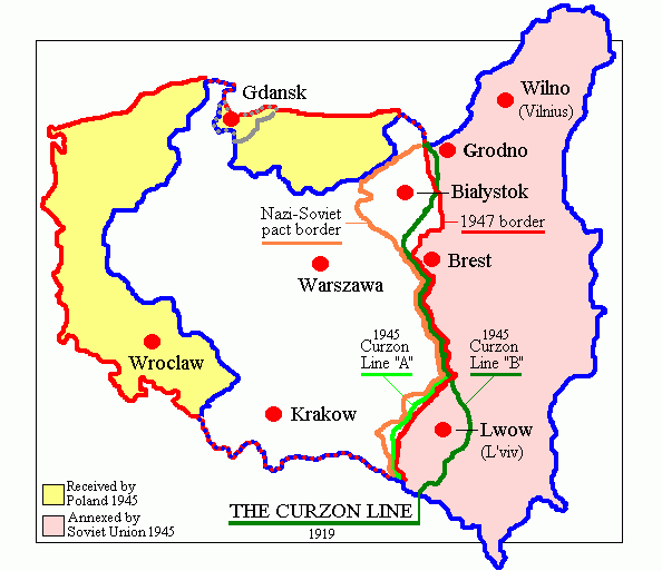
English: Map of Poland in 1945.
Deutsch: Karte Polens (1945). |
| Datum | |
| Zdroj | Vlastní dílo (originally at en.wikipedia) |
| Autor | Adam Carr |
| Další verze | Díla odvozená od tohoto souboru: Polszczyzna kresowa.png |
Licence
| |
Uživatel Adam Carr z projektu v jazyce {{{6}}}, autor tohoto díla, jej uvolnil jako volné dílo, a to celosvětově. Není-li to podle zákona možné: |
Historie souboru
Kliknutím na datum a čas se zobrazí tehdejší verze souboru.
| Datum a čas | Náhled | Rozměry | Uživatel | Komentář | |
|---|---|---|---|---|---|
| současná | 18. 6. 2018, 20:29 | | 594 × 513 (13 KB) | Julieta39 | According with 1919 maps |
| 30. 6. 2016, 05:57 |  | 594 × 513 (15 KB) | Poeticbent | r/m dead space, spelling | |
| 12. 2. 2007, 09:58 |  | 617 × 513 (9 KB) | Unomano | Map of Poland in 1945, drawn by en:User: Adam Carr. From en:Image:Map of Poland (1945).png {{PD-user-w|en|English Wikipedia|Adam Carr}} Category:Maps of the history of Poland | |
| 2. 12. 2005, 16:43 |  | 617 × 513 (9 KB) | Thuresson | Map of Poland in 1945, drawn by User: Adam Carr. From en:Image:Map of Poland (1945).png {{PD-user-w|en|English Wikipedia|Adam Carr}} Category:Historical maps of Poland |
.png)
Využití souboru
Tento soubor používá následující stránka:
Globální využití souboru
Tento soubor využívají následující wiki:
- Využití na ang.wikipedia.org
- Využití na ar.wikipedia.org
- Využití na be-tarask.wikipedia.org
- Využití na be.wikipedia.org
- Využití na bg.wikipedia.org
- Využití na ca.wikipedia.org
- Využití na de.wikibooks.org
- Využití na el.wikipedia.org
- Využití na en.wikipedia.org
- Polish People's Republic
- User:Adam Carr/My archive of original cartographic contributions
- History of German settlement in Central and Eastern Europe
- User:Landau7
- Talk:Flight and expulsion of Germans (1944–1950)/Archive 10
- Polish population transfers (1944–1946)
- User:TheNoiseBringer
- User:Halibutt/expulsion
- User:Falcaorib/Poland-Lithuania
- Využití na es.wikipedia.org
- Využití na fa.wikipedia.org
- Využití na fr.wikipedia.org
- Využití na id.wikipedia.org
- Využití na it.wikipedia.org
- Využití na kk.wikipedia.org
- Využití na lv.wikipedia.org
- Využití na nl.wikipedia.org
- Využití na pt.wikipedia.org
- Využití na ro.wikipedia.org
Zobrazit další globální využití tohoto souboru.
.png)
.png)