Soubor:British Islands.svg

Velikost tohoto PNG náhledu tohoto SVG souboru: 343 × 600 pixelů. Jiná rozlišení: 137 × 240 pixelů | 274 × 480 pixelů | 439 × 768 pixelů | 586 × 1 024 pixelů | 1 171 × 2 048 pixelů | 675 × 1 180 pixelů.
Původní soubor (soubor SVG, nominální rozměr: 675 × 1 180 pixelů, velikost souboru: 243 KB)
| Tento soubor pochází z Wikimedia Commons. Níže jsou zobrazeny informace, které obsahuje jeho tamější stránka s popisem souboru. |
Popis
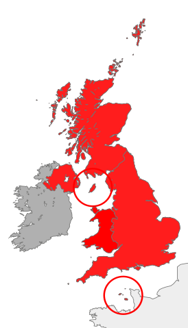
| Popis | map showing the territory referred to as "the British Islands" in relation to Great Britain and Ireland (namely the United Kingdom plus the Crown Dependencies, but not the Republic of Ireland) |
| Datum | |
| Zdroj | Vlastní dílo |
| Autor | Cnbrb |
| SVG vývoj | Tento vektorový obrázek byl vytvořen programem Inkscape. |
Licence
| Já, autor tohoto díla, jej tímto uvolňuji jako volné dílo, a to celosvětově. V některých zemích to není podle zákona možné; v takovém případě: Poskytuji komukoli právo užívat toto dílo za libovolným účelem, a to bezpodmínečně s výjimkou podmínek vyžadovaných zákonem. |
Historie souboru
Kliknutím na datum a čas se zobrazí tehdejší verze souboru.
| Datum a čas | Náhled | Rozměry | Uživatel | Komentář | |
|---|---|---|---|---|---|
| současná | 28. 10. 2016, 14:45 | | 675 × 1 180 (243 KB) | Smyth | Highlight crown dependencies, otherwise map looks identical to File:British Isles United Kingdom.svg at small sizes. |
| 20. 10. 2007, 23:32 |  | 675 × 1 180 (241 KB) | Cnbrb | == Summary == {{Information |Description=map showing the territory referred to as "the British Islands" in relation to Great Britain and Ireland (namely the United Kingdom plus the Crown Dependencies, but not the Republic of Ireland) |Source=self-made |Da |
Využití souboru
Tento soubor používá následující stránka:
Globální využití souboru
Tento soubor využívají následující wiki:
- Využití na en.wikipedia.org
- Využití na es.wikipedia.org
- Využití na fa.wikipedia.org
- Využití na fr.wiktionary.org
- Využití na he.wikipedia.org
- Využití na hu.wikipedia.org
- Využití na id.wikipedia.org
- Využití na it.wikipedia.org
- Využití na kk.wikipedia.org
- Využití na lt.wikipedia.org
- Využití na ru.wikipedia.org
- Využití na si.wikipedia.org
- Využití na sr.wikipedia.org
- Využití na sv.wikipedia.org
- Využití na tr.wikipedia.org
- Využití na uk.wikipedia.org
- Využití na vi.wikipedia.org
- Využití na zh.wikipedia.org