Soubor:AxelHeibergIslandCloseupMap.png
Větší rozlišení není k dispozici
AxelHeibergIslandCloseupMap.png (499 × 449 pixelů, velikost souboru: 13 KB, MIME typ: image/png)
| Tento soubor pochází z Wikimedia Commons. Níže jsou zobrazeny informace, které obsahuje jeho tamější stránka s popisem souboru. |
Popis
| Popis |
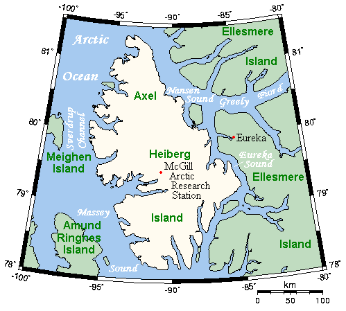
English: A map of Axel Heiberg Island, Nunavut, Canada, and surrounding islands and waterways. |
| Datum | |
| Zdroj | This map's source is here, with the uploader's modifications, and the GMT homepage says that the tools are released under the GNU General Public License. |
| Autor | Kelisi at en.wikipedia |
Licence
Kelisi from en.wikipedia.org, držitel autorských práv k tomuto dílu, ho tímto zveřejňuje za podmínek následující licence:
| Tento soubor podléhá licenci Creative Commons Uveďte autora-Zachovejte licenci 3.0 Unported. Subject to disclaimers. | ||
| Uveďte autora: Kelisi from en.wikipedia.org | ||
| ||
| Tato licenční šablona byla k tomuto souboru přidána v rámci změny licencování. |

|
Tento dokument smí být kopírován, šířen nebo upravován podle podmínek Svobodné licence GNU pro dokumenty verze 1.2 nebo libovolné vyšší verze publikované nadací Free Software Foundation. Dokument nemá neměnné části ani texty na předním či zadním přebalu. Kopie textu licence je k dispozici v oddíle nazvaném GNU Free Documentation License. Subject to disclaimers. |
Původní historie souboru
(del) (cur) 19:38, 26 March 2006 . . Kelisi (Talk) . . 499x449 (17403 bytes) (A map of Axel Heiberg Island, Nunavut, and surrounding islands and waterways. This map's source is [http://www.aquarius.ifm-geomar.de/ here], with the uploader's modifications, and the [http://gmt.soest.hawaii.edu/ GMT homepage] says that the tools are released under the GNU General Public License).
Historie souboru
Kliknutím na datum a čas se zobrazí tehdejší verze souboru.
| Datum a čas | Náhled | Rozměry | Uživatel | Komentář | |
|---|---|---|---|---|---|
| současná | 9. 11. 2007, 14:37 | | 499 × 449 (13 KB) | MaxSem | pngcrush'ed |
| 23. 4. 2006, 16:19 |  | 499 × 449 (17 KB) | MaxSem | Original description: <tt> A map of Axel Heiberg Island, Nunavut, and surrounding islands and waterways. This map's source is here, with the uploader's modifications, and the GMT homepage says that the tools are released under the GNU General Public Licen |
Využití souboru
Tento soubor používá následující stránka:
Globální využití souboru
Tento soubor využívají následující wiki:
- Využití na af.wikipedia.org
- Využití na ast.wikipedia.org
- Využití na az.wikipedia.org
- Využití na ba.wikipedia.org
- Využití na bg.wikipedia.org
- Využití na ca.wikipedia.org
- Využití na ceb.wikipedia.org
- Využití na da.wikipedia.org
- Využití na de.wikipedia.org
- Využití na en.wikipedia.org
- Využití na es.wikipedia.org
- Využití na fa.wikipedia.org
- Využití na gl.wikipedia.org
- Využití na hu.wikipedia.org
- Využití na it.wikipedia.org
- Využití na ka.wikipedia.org
- Využití na nl.wikipedia.org
- Využití na nn.wikipedia.org
- Využití na no.wikipedia.org
- Využití na pl.wikipedia.org
- Využití na pt.wikipedia.org
- Využití na ro.wikipedia.org
- Využití na ru.wikipedia.org
- Využití na simple.wikipedia.org
- Využití na sr.wikipedia.org
- Využití na uk.wikipedia.org
- Využití na vi.wikipedia.org
- Využití na war.wikipedia.org
- Využití na www.wikidata.org