Soubor:Roman Africa.JPG
Původní soubor (3 057 × 2 439 pixelů, velikost souboru: 1,95 MB, MIME typ: image/jpeg)
| Tento soubor pochází z Wikimedia Commons. Níže jsou zobrazeny informace, které obsahuje jeho tamější stránka s popisem souboru. |
Popis
| Popis |
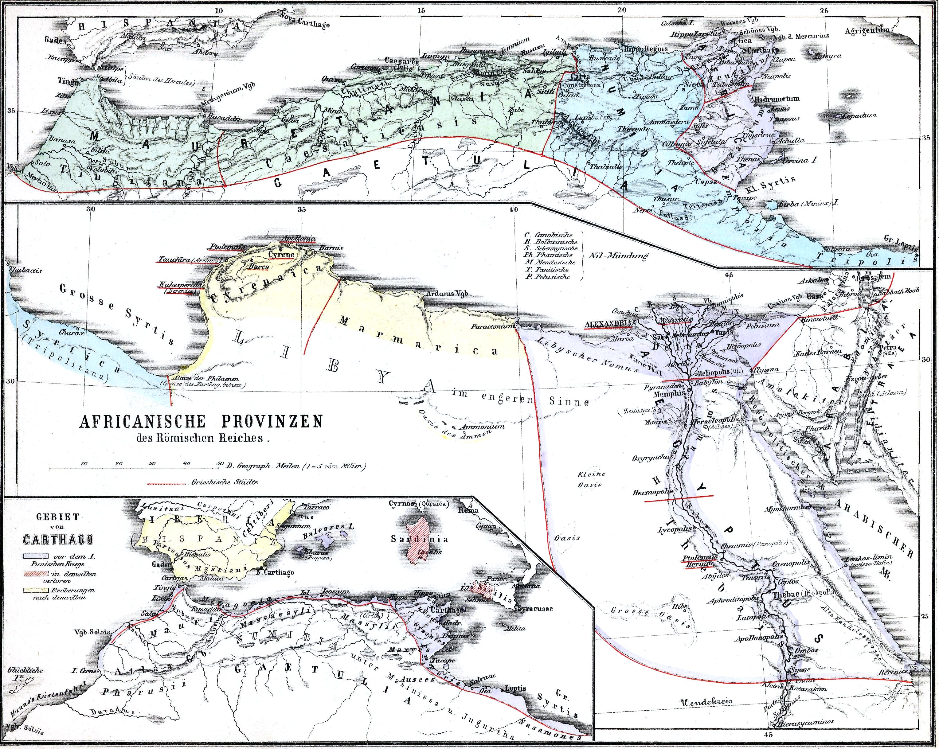
English: The African provinces of the Roman Empire. The smaller map in the lower left shows the territory of the pre-Roman state of Carthage (blue), with yellow showing conquests and hashed red indicating territory lost to Rome in the First Punic War. |
| Datum | |
| Zdroj | Historischer Schulatlas. |
| Autor | H. Kiepert |
Licence
|
Toto dílo je volné také v zemích, jejichž právní řád chrání majetková autorská práva po dobu života autora a 70 let po jeho smrti.
| |
| Bylo zjištěno, že u tohoto souboru nejsou známa žádná omezení daná autorským právem a právy s ním souvisejícími. | |
Historie souboru
Kliknutím na datum a čas se zobrazí tehdejší verze souboru.
| Datum a čas | Náhled | Rozměry | Uživatel | Komentář | |
|---|---|---|---|---|---|
| současná | 15. 11. 2009, 17:37 | | 3 057 × 2 439 (1,95 MB) | Alex:D | whitened |
| 15. 2. 2009, 00:37 |  | 3 057 × 2 439 (1,55 MB) | Olahus | {{Information |Description=Nothern Africa under Roman rule. |Source=Historischer Schulatlas. |Date=1879 |Author=H.Kiepert |Permission= |other_versions= }} {{PD-old}} Category:Old maps of Africa Category:Old maps of the Roman Empire [[Category:Maps |
Využití souboru
Tento soubor používají následující 3 stránky:
Globální využití souboru
Tento soubor využívají následující wiki:
- Využití na ar.wikipedia.org
- Využití na arz.wikipedia.org
- Využití na bg.wikipedia.org
- Využití na ca.wikipedia.org
- Využití na de.wikipedia.org
- Využití na de.wikivoyage.org
- Využití na de.wiktionary.org
- Využití na el.wikipedia.org
- Využití na en.wikipedia.org
- Numidia
- North Africa during classical antiquity
- Roman Egypt
- Byzacena
- Myos Hormos
- Tacfarinas
- List of revolutions and rebellions
- Aquae Regiae
- User:Olahus
- Uzita (Tunisia)
- El Milia
- Aggersel
- Quiza Xenitana
- Berber kings of Roman-era Tunisia
- Diocese of Maxita
- Aquae Albae in Byzacena
- Decoriana
- Simminensis (diocese)
- Zerta
- Titular Bishopric of Vita
- Elephantaria in Mauretania
- Tubia in Mauretania
- Tabuda
- Lari Castellum
- User:Ryanmhorne/pleiades List
- Ancient Africa
- Využití na eo.wikipedia.org
- Využití na es.wikipedia.org
- Využití na et.wikipedia.org
- Využití na eu.wikipedia.org
- Využití na fa.wikipedia.org
- Využití na fr.wikipedia.org
- Využití na fy.wikipedia.org
- Využití na gl.wikipedia.org
Zobrazit další globální využití tohoto souboru.