Soubor:Greatvalley-map.png

Velikost tohoto náhledu: 587 × 599 pixelů. Jiná rozlišení: 235 × 240 pixelů | 624 × 637 pixelů.
Původní soubor (624 × 637 pixelů, velikost souboru: 66 KB, MIME typ: image/png)
| Tento soubor pochází z Wikimedia Commons. Níže jsou zobrazeny informace, které obsahuje jeho tamější stránka s popisem souboru. |


|
Tento obrázek (skupina map) by měl být vytvořen pomocí vektorové grafiky jako SVG soubor. To má několik výhod; podrobnosti najdete na stránce Commons:Media for cleanup. Je-li SVG verze tohoto obrázku již k dispozici, prosím nahrajte ji. Po nahrání nahraďte tuto šablonu šablonou {{Vector version available|jméno nového obrázku.svg}}.
|
Popis
| Popis |
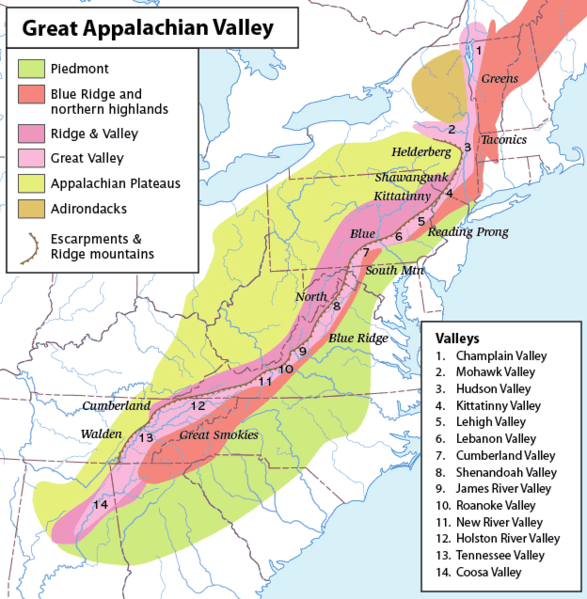
Map of the Appalachian Mountain physiographic regions, highlighting the Great Appalachian Valley, naming the main valleys making it up and the main mountains on either side. Legend:
|
| Datum | (UTC) |
| Zdroj | |
| Autor |
|
| Toto je upravený obrázek, což znamená, že byl oproti původní verzi digitálně změněn. Úpravy: converted loselessto PNG. Původní verzi je možné zhlédnout zde: Greatvalley-map.jpg.
|
Já, držitel autorských práv k tomuto dílu, ho tímto zveřejňuji za podmínek následující licence:
Tento soubor podléhá licenci Creative Commons Uveďte autora-Zachovejte licenci 2.5 Generic
- Dílo smíte:
- šířit – kopírovat, distribuovat a sdělovat veřejnosti
- upravovat – pozměňovat, doplňovat, využívat celé nebo částečně v jiných dílech
- Za těchto podmínek:
- uveďte autora – Máte povinnost uvést autorství, poskytnout odkaz na licenci a uvést, pokud jste provedli změny. Toho můžete docílit jakýmkoli rozumným způsobem, avšak ne způsobem naznačujícím, že by poskytovatel licence schvaloval nebo podporoval vás nebo vaše užití díla.
- zachovejte licenci – Pokud tento materiál jakkoliv upravíte, přepracujete nebo použijete ve svém díle, musíte své příspěvky šířit pod stejnou nebo slučitelnou licencí jako originál.
Původní historie souboru
This image is a derivative work of the following images:
- File:Greatvalley-map.jpg licensed with Cc-by-sa-2.5
- 2006-11-14T06:22:37Z Pfly 624x637 (394372 Bytes) {{Information |Description=Map of the Appalachian Mountain physiographic regions, highlighting the Great Appalachian Valley, naming the main valleys making it up and the main mountains on either side. |Source=I made this map
Uploaded with derivativeFX
Historie souboru
Kliknutím na datum a čas se zobrazí tehdejší verze souboru.
| Datum a čas | Náhled | Rozměry | Uživatel | Komentář | |
|---|---|---|---|---|---|
| současná | 12. 5. 2010, 17:00 | | 624 × 637 (66 KB) | Perhelion | {{Information |Description=Map of the Appalachian Mountain physiographic regions, highlighting the Great Appalachian Valley, naming the main valleys making it up and the main mountains on either side. |Source=*File:Greatvalley-map.jpg |Date=2010-05- |
Využití souboru
Tento soubor používá následující stránka:
Globální využití souboru
Tento soubor využívají následující wiki:
- Využití na bg.wikipedia.org
- Využití na bh.wikipedia.org
- Využití na ca.wikipedia.org
- Využití na da.wikipedia.org
- Využití na en.wikipedia.org
- Washington County, New York
- Great Appalachian Valley
- Allegheny Front
- Lehigh Valley
- Cumberland Valley
- Talk:Ridge-and-Valley Appalachians
- Lebanon Valley
- Kittatinny Valley
- Gaps of the Allegheny
- Template:User Appalachian diaspora
- User:Hike395/mountain bot diff
- Template:Infobox mountain/test versus status quo ante 3
- Využití na et.wikipedia.org
- Využití na fa.wikipedia.org
- Využití na fo.wikipedia.org
- Využití na frr.wikipedia.org
- Využití na fr.wikipedia.org
- Využití na he.wikipedia.org
- Využití na it.wikipedia.org
- Využití na ja.wikipedia.org
- Využití na lt.wikipedia.org
- Využití na ml.wikipedia.org
- Využití na pl.wikipedia.org
- Využití na simple.wikipedia.org
- Využití na uk.wikipedia.org