Soubor:Gaeltacht.svg

Velikost tohoto PNG náhledu tohoto SVG souboru: 467 × 599 pixelů. Jiná rozlišení: 187 × 240 pixelů | 374 × 480 pixelů | 598 × 768 pixelů | 798 × 1 024 pixelů | 1 595 × 2 048 pixelů | 906 × 1 163 pixelů.
Původní soubor (soubor SVG, nominální rozměr: 906 × 1 163 pixelů, velikost souboru: 72 KB)
| Tento soubor pochází z Wikimedia Commons. Níže jsou zobrazeny informace, které obsahuje jeho tamější stránka s popisem souboru. |
Popis
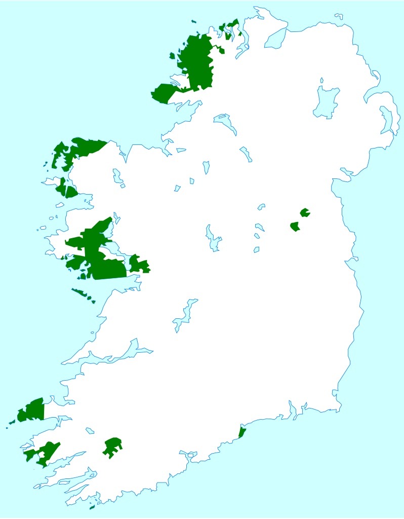
| Popis | Map showing the Gaeltacht areas of Ireland |
| Datum | |
| Zdroj | Own work, based on data from http://www.udaras.ie/ and http://www.gaelsaoire.ie/default.asp. Base map is Image:Blank Ireland.png |
| Autor | Angr |
| Svolení (Užití tohoto souboru) |
Multilicensed under GFDL and CC-BY-SA |
Licence
Já, držitel autorských práv k tomuto dílu, ho tímto zveřejňuji za podmínek následujících licencí:

|
Tento dokument smí být kopírován, šířen nebo upravován podle podmínek Svobodné licence GNU pro dokumenty verze 1.2 nebo libovolné vyšší verze publikované nadací Free Software Foundation. Dokument nemá neměnné části ani texty na předním či zadním přebalu. Kopie textu licence je k dispozici v oddíle nazvaném GNU Free Documentation License. |
| Tento soubor podléhá licenci Creative Commons Uveďte autora-Zachovejte licenci 3.0 Unported | ||
| ||
| Tato licenční šablona byla k tomuto souboru přidána v rámci změny licencování. |
Tento soubor podléhá licenci Creative Commons Uveďte autora 2.5 Generic
- Dílo smíte:
- šířit – kopírovat, distribuovat a sdělovat veřejnosti
- upravovat – pozměňovat, doplňovat, využívat celé nebo částečně v jiných dílech
- Za těchto podmínek:
- uveďte autora – Máte povinnost uvést autorství, poskytnout odkaz na licenci a uvést, pokud jste provedli změny. Toho můžete docílit jakýmkoli rozumným způsobem, avšak ne způsobem naznačujícím, že by poskytovatel licence schvaloval nebo podporoval vás nebo vaše užití díla.
Můžete si zvolit libovolnou z těchto licencí.
Historie souboru
Kliknutím na datum a čas se zobrazí tehdejší verze souboru.
| Datum a čas | Náhled | Rozměry | Uživatel | Komentář | |
|---|---|---|---|---|---|
| současná | 10. 9. 2006, 17:05 | | 906 × 1 163 (72 KB) | Mahagaja | == Summary == {{Information |Description=Map showing the Gaeltacht areas of Ireland |Source=Own work, based on data from http://www.udaras.ie/ and http://www.gaelsaoire.ie/default.asp. Base map is Image:Blank Ireland.png |Date=17 Augu |
Využití souboru
Tento soubor používá následující stránka:
Globální využití souboru
Tento soubor využívají následující wiki:
- Využití na als.wikipedia.org
- Využití na ang.wikipedia.org
- Využití na bg.wikipedia.org
- Využití na br.wikipedia.org
- Využití na cy.wikipedia.org
- Využití na da.wikipedia.org
- Využití na de.wikipedia.org
- Využití na de.wiktionary.org
- Využití na dsb.wikipedia.org
- Využití na el.wiktionary.org
- Využití na en.wikipedia.org
- Využití na en.wikibooks.org
- Využití na en.wikiversity.org
- Využití na eo.wikipedia.org
- Využití na ext.wikipedia.org
- Využití na fiu-vro.wikipedia.org
- Využití na fi.wikibooks.org
- Využití na fo.wikipedia.org
- Využití na fr.wikipedia.org
- Využití na fur.wikipedia.org
- Využití na fy.wikipedia.org
- Využití na ga.wikipedia.org
- Využití na gv.wikipedia.org
- Využití na he.wikipedia.org
- Využití na hsb.wikipedia.org
- Využití na is.wikipedia.org
- Využití na it.wikipedia.org
- Využití na ja.wikipedia.org
- Využití na ka.wikipedia.org
- Využití na kk.wikipedia.org
- Využití na ko.wikibooks.org
- Využití na ku.wikipedia.org
- Využití na la.wikipedia.org
- Využití na lmo.wikipedia.org
- Využití na lt.wikipedia.org
- Využití na nn.wikipedia.org
Zobrazit další globální využití tohoto souboru.